K
Kathleen Martin
Guest
NASA has partnered with other US agencies and a Colorado-based drone manufacturer to create a UAV-based system to observe volcanoes for indications of what otherwise might be unexpected, catastrophic eruptions for local communities.
NASA has long been interested in deploying drones to replace human monitors and small aircraft habitually used for near-range examination of volcano activity and for gathering evidence of approaching eruptions. Tipped off to those by data collected with sensors on the craft, scientists could issue advance warnings when craters are getting ready to blow, as Cumbre Vieja on Spain’s La Palma, Karkatau in Indonesia, and Hawai‘i Island’s Kīleaua all did last year.
Though the tech presumably wouldn’t be applicable to the underwater explosion of Hunga Tonga-Hunga Ha’apai that produced a calamitous tsunami for the people of Tonga, it would allow researchers to predict other looming eruptions – allowing local communities to prepare or evacuate beforehand.
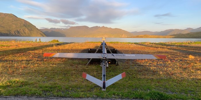
NASA’s first efforts to develop UAVs for that purpose date back to 2013, when a small craft was used to overfly the Turrialba Volcano in Costa Rica. The agency later struck up a long-running partnership with Black Wing Technologies, which produces drone systems for rugged enterprise and research applications. Their work eventually led to the creation of the S2 fixed-wing, fully autonomous plane that was prepared for data collection flights above the Aleutian Islands’ Makushin Volcano.
Along the way, the project was joined by the US Geological Survey (USGS), which provided additional sensors to capture visual and thermal images, and detect a fuller range of volcanic gases. The S2 took to the air in a series of missions above Makushin last September.
Continue reading: https://dronedj.com/2022/01/31/nasa-developing-drones-to-monitor-potential-volcano-eruptions/
NASA has long been interested in deploying drones to replace human monitors and small aircraft habitually used for near-range examination of volcano activity and for gathering evidence of approaching eruptions. Tipped off to those by data collected with sensors on the craft, scientists could issue advance warnings when craters are getting ready to blow, as Cumbre Vieja on Spain’s La Palma, Karkatau in Indonesia, and Hawai‘i Island’s Kīleaua all did last year.
Though the tech presumably wouldn’t be applicable to the underwater explosion of Hunga Tonga-Hunga Ha’apai that produced a calamitous tsunami for the people of Tonga, it would allow researchers to predict other looming eruptions – allowing local communities to prepare or evacuate beforehand.
NASA’s first efforts to develop UAVs for that purpose date back to 2013, when a small craft was used to overfly the Turrialba Volcano in Costa Rica. The agency later struck up a long-running partnership with Black Wing Technologies, which produces drone systems for rugged enterprise and research applications. Their work eventually led to the creation of the S2 fixed-wing, fully autonomous plane that was prepared for data collection flights above the Aleutian Islands’ Makushin Volcano.
Along the way, the project was joined by the US Geological Survey (USGS), which provided additional sensors to capture visual and thermal images, and detect a fuller range of volcanic gases. The S2 took to the air in a series of missions above Makushin last September.
To make the ground-breaking Makushin flights possible, however, the team had to convince the Federal Aviation Administration (FAA) to grant beyond visual line of sight (BVLOS) exemptions to enable the S2’s 15-mile flights to the cone.“We needed it to be really rugged, to withstand flying in the turbulent conditions and corrosive gases around volcanoes,” said Florian Schwandner, director of the Earth Sciences division at NASA’s Ames Research Center. “We also developed a gas-sensing payload the UAS could carry to look for signs of volcanic unrest.”
Continue reading: https://dronedj.com/2022/01/31/nasa-developing-drones-to-monitor-potential-volcano-eruptions/