K
Kathleen Martin
Guest
Natural calamities such as floods, earthquakes, diseases, severe temperatures, pest infestations, volcanoes, storms, and wildfires, to name a few, have a negative impact on many countries on a yearly basis. New technology-based disaster response & mitigation is being curated by IG Drones to improve the efficiency and efficacy of first responders’ aid in emergency response & disaster mapping. They’ve proved their mettle during various national disasters – Assam Floods, Amphan Cyclone, Fani Cyclone & Jajpur Flood in Odisha, Maharashtra Flood, Uttarakhand CloudBurst using drone & geospatial technology saving hundreds and thousands of lives.
From 2010 to 2019, there were 119 climate and weather events that cost $1 billion or more, causing an average of $80.2 billion in damage per year. The decade before that (2000–2009) saw only 59 billion-dollar events in India, at an average cost of $52 billion.
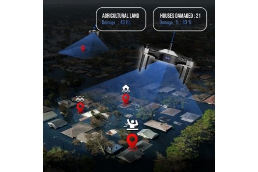
In light of high cost of operations of aircraft, a number of search and rescue organisations have begun to test the use of drone technology to aid both land and water-based rescues, likewise of which was carried out by IG Drones during Chamoli Disaster & Jajpur Floods by the help of the Thermal Imaging Camera Payload fitted on drones.
Furthermore, the recent development of a SaaS global platform designed by IG Drones for unmanned aviation has proven to be a boon for the disaster management society. The SaaS platform also performs a critical function: it aids in the interpolation of micro-level high-resolution drone data with low-resolution satellite imagery data. SaaS Platform for the analysed Drone data has helped various stakeholders in the pre & post-disaster ecosystem ranging from Disaster Management Authorities till Humanitarian Organizations, Growers and banking institutions to help bring all relevant players together in an integrated framework. It has crowned them as the India’s best Drone Consultant. They’ve developed a risk and damage assessment survey protocol in close assistance with top brass of various stakeholders, as communicated by officials from IG Drones.
Continue reading: https://edtimes.in/ig-drones-are-taking-to-the-skies-by-using-drones-in-disaster-management/
From 2010 to 2019, there were 119 climate and weather events that cost $1 billion or more, causing an average of $80.2 billion in damage per year. The decade before that (2000–2009) saw only 59 billion-dollar events in India, at an average cost of $52 billion.
In light of high cost of operations of aircraft, a number of search and rescue organisations have begun to test the use of drone technology to aid both land and water-based rescues, likewise of which was carried out by IG Drones during Chamoli Disaster & Jajpur Floods by the help of the Thermal Imaging Camera Payload fitted on drones.
Furthermore, the recent development of a SaaS global platform designed by IG Drones for unmanned aviation has proven to be a boon for the disaster management society. The SaaS platform also performs a critical function: it aids in the interpolation of micro-level high-resolution drone data with low-resolution satellite imagery data. SaaS Platform for the analysed Drone data has helped various stakeholders in the pre & post-disaster ecosystem ranging from Disaster Management Authorities till Humanitarian Organizations, Growers and banking institutions to help bring all relevant players together in an integrated framework. It has crowned them as the India’s best Drone Consultant. They’ve developed a risk and damage assessment survey protocol in close assistance with top brass of various stakeholders, as communicated by officials from IG Drones.
Continue reading: https://edtimes.in/ig-drones-are-taking-to-the-skies-by-using-drones-in-disaster-management/