K
Kathleen Martin
Guest
It often goes unacknowledged that construction was one of the earliest data-focused industries. Understanding measurements of the worksite, material quantities and progress has been core to projects as old as the Roman Coliseum and as new as the Navi Mumbai International Airport currently under construction. What’s changed is the way we gather and use the data and fortunately, we’ve gotten much better at it.
Here’s one way to think about it: data is there whether we take it or not. It’s the extra earth sitting on site that wasn’t included in the pre-bid survey, it’s the pile of materials waiting to be used that turns out to be short, and it’s the foundation that was laid just inches off spec. Gathering this data simply gives contractors a heads up to these unforeseen challenges so we can manage them as early as possible, before they become more expensive, time-intensive problems. On today’s construction sites, lack of project data costs businesses more than $177B annually.
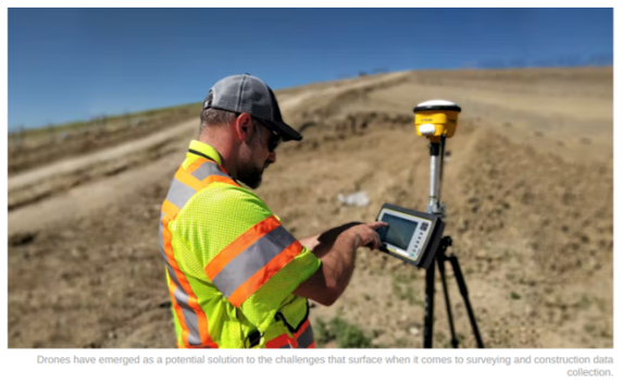
Traditional Surveying Versus Drone Surveying
Notably, it’s not just the action of gathering the data that’s feeding into these huge costs. So much of the data gathered on worksites today through techniques like traditional surveying includes delays or discrepancies that allow problems to go unrecognized for too long. Surveys executed through traditional methods often contradict one another or come in weeks after a critical decision was made, unaided by the relevant information gathered during the survey.
Drones have emerged as a solution to these issues and are facilitating more real-time, accurate survey data. They are especially efficient for large site surveying for projects like highways and airports that are highly time intensive to have an individual walk around and gather survey measurements manually. Drone surveys are also contributing to more visual site communication by providing assets like 3D site maps created through photogrammetry that can give every team and contractor the same view of the site and an indisputable source of truth from which to make decisions.
D.H. Griffin Infrastructure, a division of D.H. Griffin that provides site grading and development, specialty concrete and underground utility services in North Carolina was seeking to get a clearer look into their sites to bid more accurately. The estimation department needed a more reliable, precise, and easy to implement source of truth after they experienced issues approximating the scope of new jobs.
“We had run into some problems where we bid a project and found out there was more or less dirt than we anticipated,” said Keith Taylor, the survey manager.
Continue reading: https://www.forconstructionpros.com/construction-technology/article/22105693/propeller-aero-harnessing-the-data-behind-your-worksite-through-drone-surveying
Here’s one way to think about it: data is there whether we take it or not. It’s the extra earth sitting on site that wasn’t included in the pre-bid survey, it’s the pile of materials waiting to be used that turns out to be short, and it’s the foundation that was laid just inches off spec. Gathering this data simply gives contractors a heads up to these unforeseen challenges so we can manage them as early as possible, before they become more expensive, time-intensive problems. On today’s construction sites, lack of project data costs businesses more than $177B annually.
Traditional Surveying Versus Drone Surveying
Notably, it’s not just the action of gathering the data that’s feeding into these huge costs. So much of the data gathered on worksites today through techniques like traditional surveying includes delays or discrepancies that allow problems to go unrecognized for too long. Surveys executed through traditional methods often contradict one another or come in weeks after a critical decision was made, unaided by the relevant information gathered during the survey.
Drones have emerged as a solution to these issues and are facilitating more real-time, accurate survey data. They are especially efficient for large site surveying for projects like highways and airports that are highly time intensive to have an individual walk around and gather survey measurements manually. Drone surveys are also contributing to more visual site communication by providing assets like 3D site maps created through photogrammetry that can give every team and contractor the same view of the site and an indisputable source of truth from which to make decisions.
D.H. Griffin Infrastructure, a division of D.H. Griffin that provides site grading and development, specialty concrete and underground utility services in North Carolina was seeking to get a clearer look into their sites to bid more accurately. The estimation department needed a more reliable, precise, and easy to implement source of truth after they experienced issues approximating the scope of new jobs.
“We had run into some problems where we bid a project and found out there was more or less dirt than we anticipated,” said Keith Taylor, the survey manager.
Continue reading: https://www.forconstructionpros.com/construction-technology/article/22105693/propeller-aero-harnessing-the-data-behind-your-worksite-through-drone-surveying