K
Kathleen Martin
Guest
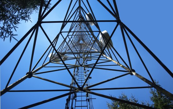
UAS are proving to be a powerful tool for ensuring the success and safety of all sorts of infrastructure. Drones can be operated at a fraction of the cost of traditional inspection crews, and, when equipped with the latest technologies, they can deliver the highest quality in imaging and positioning data. In 2021, Commercial UAV News held the "Hard to Reach Places" webinar to provide an overview of the opportunities, barriers, and successful use cases with a key focus on the latest technologies and project results. To discuss this, CUAV invited Jeremy Sofonia from Emesent, Rese Cleaver from DroneUp, Marc Flamm from Skydio, and Conor Ferguson from WISPr Systems.
Emesent's Hovermap is a lightweight (around 400 pounds) mobile lidar mapping payload that uses Velodyne's VLP 16 Puck LIDAR sensor. It utilizes SLAM algorithms to operate in GPS denied environments and some advanced autonomy algorithms for collision avoidance and other autonomy features. During the webinar, Sofonia focused on safety, efficiency, cost-effectiveness, and new insights for drones in asset management. One of the things that Hovermap excels at is in versatility and deployment options since it mounts on a drone, but it also mounts on Boston Dynamics' SPOT, a backpack, a protective cage, or even on a vehicle. With a single purchase, users can access many different applications for infrastructure inspections, such as mining, rail and road, plenty of indoor locations, search and rescue, and urban environments.
To demonstrate how Hovermap works within hard-to-reach places, which in many cases are GPS denied environments when it comes to drone operations, Sofonia showcased some of Emesent's operations. These included scans of a one-kilometer underground mine, a pump house at a hydroelectric station, an indoor stockpile at night, and the above and below ground data collected in a single scan of a substation in Stuttgart, Germany.
"One of the ways that we do this is through our fully autonomous BVLOS advanced systems," Sofonia said. "We collect a real-time point cloud that's fed back to the operator, as long as we can maintain the communication over the drone, allowing us to navigate these GPS denied environments easily, especially with our tap-to-fly kind of approach on the tablet with live map streaming. We also have safety features, like a smart return to home feature when the battery gets low, or if there's too much dust, and collision avoidance to detect and avoid even the smallest obstacles."
According to Sofonia, one of the highlights of Emesent's technology is its processing times, where a 20-minute scan corresponds to a 20-minute point cloud post-processing. Also, its capabilities of merging the data into a single unified cloud are "ahead of the class as far as their ease of use and capabilities."
Cleaver talked about the drone market landscape and how drones will bring considerable value to the infrastructure industry. She believes drones will make the most difference in three critical points: cost, location, and workforce. In terms of cost, Cleaver stated drones are way cheaper than keeping up a whole team of people out somewhere. They also capture high-resolution data within a shorter period than traditional means, easily reach high and tight places that are unsafe, and improve early detection of issues, leading to reduced maintenance costs. Then we have location, where drones eliminate the site-to-site travel time and provide quick and easy access to remote structures, improving the monitoring regularity and optimizing asset performance. For example, DroneUp is seeing an average of eight inspections a day using drones instead of three. Finally, with site-to-site travel eliminated, infrastructure teams can perform meaningful work.
Continue reading: https://www.commercialuavnews.com/infrastructure/hard-to-reach-places-smart-drones-making-infrastructure-inspection-safer